
Remote Sensing & GIS Careers in India
Table of Contents
Introduction:
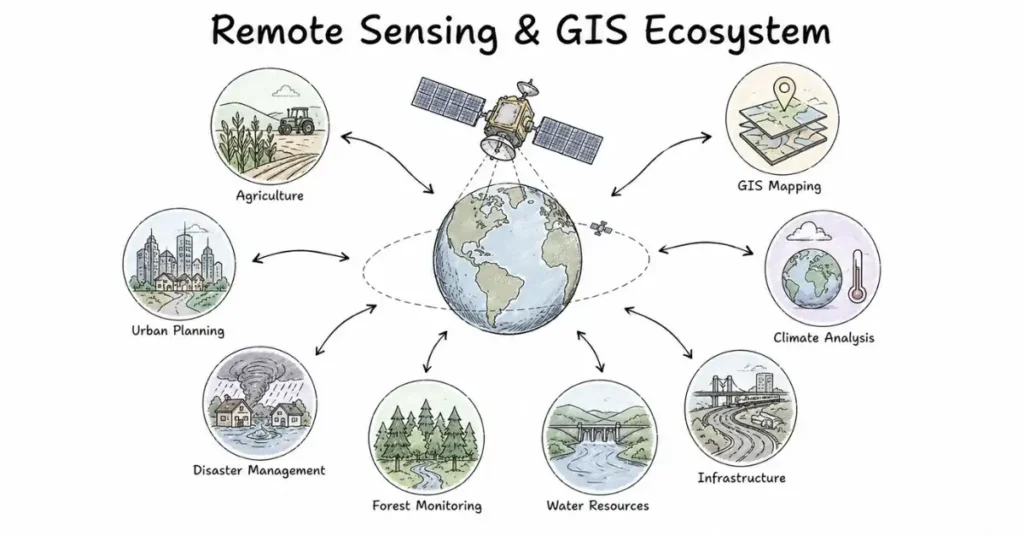
Not every space career involves building rockets or designing satellites. Some of the most impactful space jobs in India today involve something much more accessible: making sense of the data that satellites send back.
Every day, ISRO’s earth observation satellites pass over Indian territory multiple times, capturing images and measurements of farmland, forests, coastlines, rivers, urban areas, and disaster zones. That raw data means nothing until someone processes it, analyses it, and turns it into something a farmer, a city planner, or a disaster management team can actually use.
That work converting satellite data into real-world decisions is remote sensing and GIS. And it is one of the most open, most in-demand, and most underexplored entry points into India’s space sector.
What Is Remote Sensing and GIS?
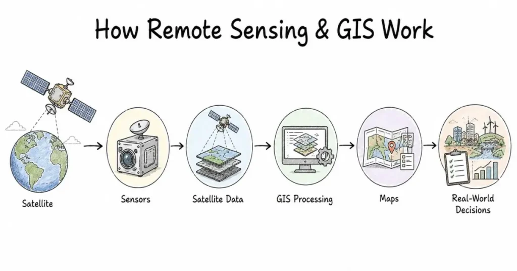
Remote sensing is the science of collecting information about the Earth’s surface from a distance primarily from satellites and aircraft. Satellites carry sensors that detect different types of energy reflected or emitted from Earth’s surface: visible light, infrared, microwave, and hyperspectral bands. Different surfaces crops, water, concrete, soil reflect energy differently, which is how satellites can tell a healthy wheat field from a diseased one, or a flooded road from a dry one.
GIS (Geographic Information Systems) is the framework for storing, managing, analysing, and visualising geographic data. A GIS analyst combines satellite imagery with maps, demographic data, infrastructure records, and other spatial data layers to answer location-based questions: Where is the flood spreading? Which areas have the highest drought risk? Where should the next highway be built?
Together, remote sensing and GIS form the foundation of almost every satellite data application in use in India today.
Where Remote Sensing and GIS Is Used in India
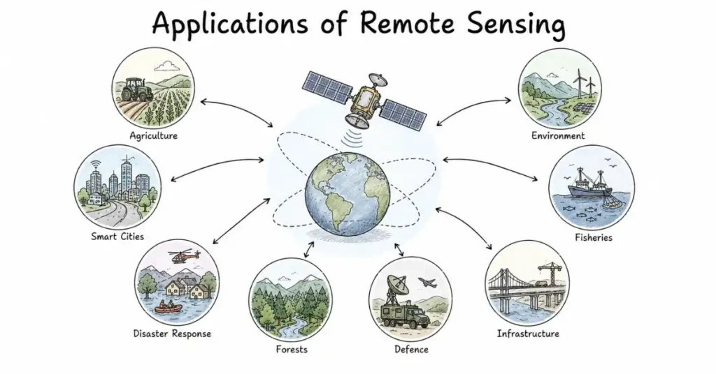
Understanding the application areas helps you understand where the jobs are:
Agriculture: Crop mapping, yield estimation, soil moisture monitoring, crop disease detection. Banks use satellite data to assess farmer loan eligibility. Insurance companies use it to settle crop damage claims without sending a human assessor.
Urban planning: Monitoring urban sprawl, tracking illegal construction, planning infrastructure, assessing green cover.
Disaster management: Flood mapping, cyclone tracking, landslide risk assessment, post-disaster damage assessment. ISRO’s NRSC provides satellite-derived maps to NDMA and state governments during every major disaster.
Forest and environment monitoring: Deforestation detection, wildlife habitat mapping, carbon stock assessment.
Defence and border management: ISRO provides earth observation services to India’s armed forces and border security agencies.
Infrastructure and utilities: Pipeline monitoring, road condition assessment, power grid planning.
Fisheries: Ocean colour satellites help fishing communities identify where fish are concentrated ISRO’s Potential Fishing Zone (PFZ) advisory service uses satellite data to help fishing boats.
Each of these application areas is an employer. Jobs exist not just at ISRO they exist at state governments, agriculture companies, insurance firms, infrastructure developers, and defence agencies.
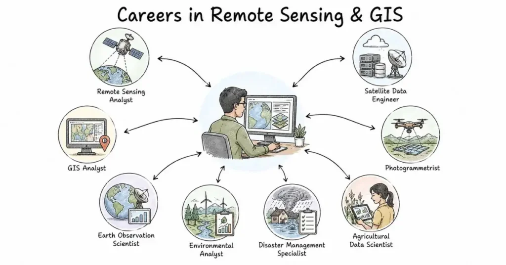
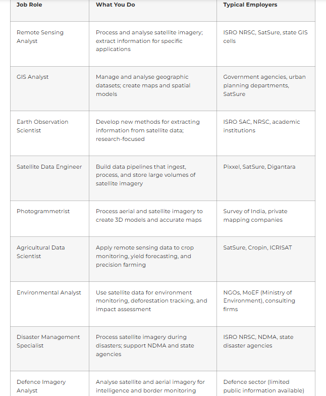
Key Job Roles in Remote Sensing and GIS
Top Employers for Remote Sensing and GIS Professionals
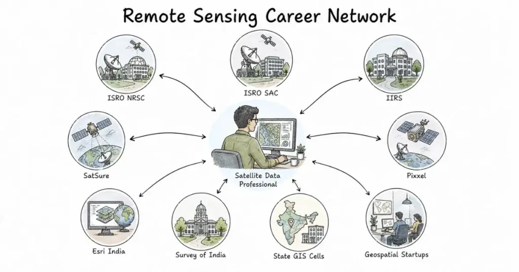
ISRO NRSC (National Remote Sensing Centre, Hyderabad)
NRSC is India’s dedicated centre for satellite remote sensing data acquisition, processing, and dissemination. It operates India’s ground receiving stations for earth observation data, runs the BHUVAN geoportal, and provides satellite-derived products to government agencies across the country. Hyderabad-based highly relevant for Telangana candidates. Entry through ICRB recruitment.
ISRO SAC (Space Applications Centre, Ahmedabad)
SAC develops the payloads (cameras and sensors) on ISRO’s earth observation satellites and builds the application tools that use their data. Scientists and engineers here work on both the satellite hardware and the data analysis side.
ISRO IIRS (Indian Institute of Remote Sensing, Dehradun)
IIRS is ISRO’s training and research institute for remote sensing and GIS. It runs postgraduate diploma programs, M.Sc. programs (in collaboration with Andhra University), and short-term training courses. Working here means training the next generation of remote sensing professionals while contributing to applied research.
SatSure (Bengaluru)
India’s leading satellite data analytics startup. SatSure builds decision-intelligence platforms for agriculture lending, infrastructure monitoring, and environmental assessment. Strong Python, machine learning, and remote sensing skill requirements. One of the most accessible private-sector entry points for remote sensing graduates.
Pixxel (Bengaluru)
Pixxel’s hyperspectral satellites generate data that requires specialised analysts to process and interpret. Their data science and remote sensing teams work on applications ranging from precision agriculture to mineral exploration to environmental monitoring.
Esri India (Noida)
Esri is the company behind ArcGIS the most widely used GIS software platform in the world. Esri India hires GIS analysts, solution engineers, and technical consultants who deploy GIS solutions for government and enterprise clients
Trimble India
Provides GIS, surveying, and mapping technology solutions. Hires GIS engineers and field data collection specialists.
State Government GIS Cells
Nearly every Indian state now has a GIS or Spatial Data Infrastructure cell in urban development departments, revenue departments, forest departments, and agriculture departments. These are relatively underexplored government employers with consistent demand for GIS professionals.
Survey of India
India’s national mapping agency. Hires photogrammetrists, cartographers, and GIS analysts for national mapping programs.
Remote Sensing and GIS Salary in India
Experience Level | Salary Range |
Fresher (0–2 years) | ₹3.5–6 LPA (private); ₹56,100/month base (ISRO) |
Mid-level (3–6 years) | ₹8–18 LPA |
Senior (6+ years) | ₹18–30 LPA |
Specialist / Lead (domain expert) | ₹25–40 LPA |
Remote sensing and GIS salaries at the entry level are slightly lower than core aerospace or software engineering roles. However, professionals who combine remote sensing expertise with strong Python and machine learning skills particularly for agricultural or environmental analytics see faster salary growth as this combination is genuinely rare and in high demand at companies like SatSure and Pixxel.
Skills You Need to Build
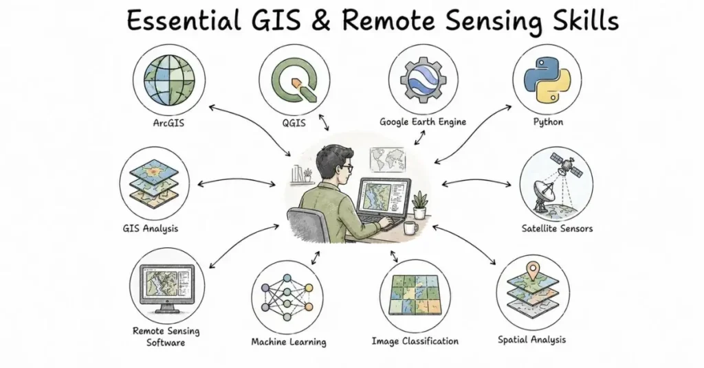
Core technical skills:
- GIS software: ArcGIS (industry standard, widely used in government) and QGIS (open-source, free, widely used in startups and research). You need to know at least one well.
- Remote sensing software: ERDAS Imagine, ENVI, or eCognition for image processing and classification. Google Earth Engine (GEE) is increasingly important it is cloud-based, free, and handles large volumes of satellite data efficiently.
- Python programming: Essential for automating GIS workflows, processing large satellite datasets, and building analytical pipelines. Libraries like GDAL, Rasterio, Geopandas, and Shapely are the core tools. Machine learning libraries (scikit-learn, TensorFlow) are increasingly expected for data science roles.
- Understanding of satellite sensors: Know the difference between multispectral, hyperspectral, SAR (Synthetic Aperture Radar), and thermal sensors. Know India’s key earth observation satellites: ResourceSat, CartoSat, OceanSat, HysIS, RISAT.
- Image classification and interpretation: Supervised and unsupervised classification methods, accuracy assessment, change detection techniques.
Domain knowledge (pick one to specialise in):
Agricultural remote sensing, urban mapping, disaster management, ocean applications, or forest monitoring. Employers value people who understand both the satellite data and the domain problem it is solving.
Degrees and Qualifications That Work
Remote sensing and GIS is one of the most accessible career tracks in the space sector because it accepts candidates from several different educational backgrounds:
Strong undergraduate entries:
- B.Tech in ECE, Computer Science, or Geoinformatics
- B.Sc. in Geography, Environmental Science, or Physics
- B.E. in Civil Engineering (strong GIS relevance for infrastructure applications)
Postgraduate programs that open doors:
- M.Tech in Remote Sensing and GIS offered at Anna University Chennai, Andhra University, Osmania University Hyderabad, and several others
- M.Sc. in Geoinformatics Pune University, Symbiosis, BHU
- PG Diploma in Remote Sensing and GIS IIRS Dehradun (ISRO’s own institute; highly respected and directly connected to ISRO hiring pipelines)
- IIRS also offers online certificate courses in remote sensing and GIS accessible to anyone with a science or engineering background
The IIRS PG Diploma is particularly worth highlighting for students in Hyderabad and nearby areas: it is run directly by ISRO, the faculty are ISRO scientists, and the network you build there directly connects to NRSC (which is also in Hyderabad).
Google Earth Engine The Skill That Changes Everything
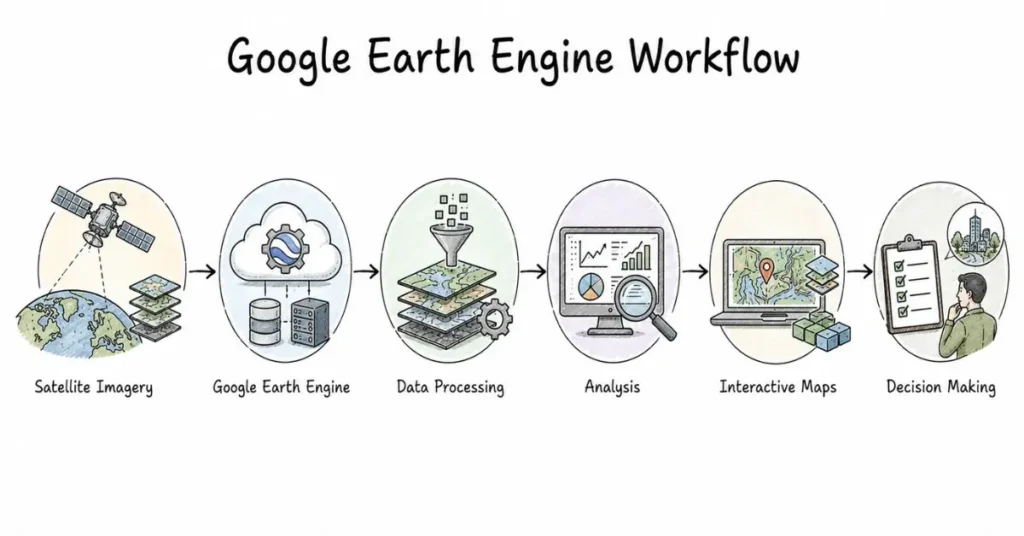
If there is one skill that will most rapidly improve your employability in remote sensing right now, it is Google Earth Engine (GEE).
GEE is a cloud-based geospatial analysis platform that gives you access to petabytes of satellite imagery decades of Landsat, Sentinel, MODIS, and other data without downloading anything. You write JavaScript or Python code to query, process, and analyse satellite data at global scale.
Before GEE, analysing a year’s worth of satellite imagery for all of India required expensive hardware and days of processing. With GEE, a student with a laptop can do the same analysis in minutes. This has democratised remote sensing research and employers know it.
A strong GEE project on your resume say, mapping paddy crop extent across Telangana using Sentinel-1 SAR data, or detecting urban expansion in Hyderabad using Landsat time series is genuinely impressive to every employer in this space, including ISRO.
GEE has a free academic account. Start learning it now.
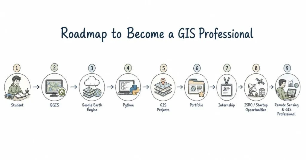
How to Break Into Remote Sensing and GIS Step by Step
Step 1: Learn QGIS first (it is free)
QGIS is open-source and free. It covers 90% of what ArcGIS does. Complete the official QGIS training manual. Build two or three projects using publicly available data flood mapping, crop area estimation, urban growth analysis.
Step 2: Learn Google Earth Engine
Sign up for a free GEE academic account. Complete the official GEE tutorial series. Build one substantive project using Indian satellite data and document it thoroughly.
Step 3: Learn Python for geospatial work
Rasterio, GDAL, Geopandas, and Shapely are the core libraries. A course like “Python for Geospatial Analysis” on Udemy or Coursera covers these directly. Combine this with the GEE Python API.
Step 4: Build a portfolio of real projects
Three solid projects one agricultural, one urban, one environmental using real Indian data demonstrate more practical ability than any degree certificate. Put these on GitHub with clear documentation.
Step 5: Apply to IIRS for short courses or the PG Diploma
IIRS Dehradun offers both in-person and online programs. Even a short IIRS certificate adds credibility and puts you in direct contact with ISRO’s remote sensing community.
Step 6: Target NRSC internships
NRSC in Hyderabad takes interns for remote sensing and GIS projects. An NRSC internship is one of the strongest credentials you can have when applying for jobs in this field.
FAQs : Remote Sensing and GIS Careers in India
Q: Can a geography graduate get a job in remote sensing without an engineering degree?
Yes, and this is one of the few career tracks in the space sector where this is genuinely true. Geography, environmental science, and physics graduates with strong GIS and Python skills are actively hired by SatSure, state GIS cells, Esri India, and research institutions. The IIRS PG Diploma is the recommended bridge qualification.
Q: Is remote sensing only relevant for government jobs?
Not at all. The private sector demand for remote sensing skills is growing faster than government hiring right now. SatSure, Pixxel, Cropin, Fasal, and dozens of agritech and climate tech startups need remote sensing analysts. Insurance companies are building satellite-based crop assessment teams. The private market is large and growing.
Q: How is remote sensing different from photogrammetry?
Remote sensing is broadly about extracting information from satellite and aerial data. Photogrammetry is specifically about measuring physical dimensions from images creating accurate 3D models, elevation maps, and precise measurements. There is overlap, but photogrammetry is more specialised and heavily used in surveying, construction, and infrastructure projects.
Q: What is the scope for remote sensing in Hyderabad specifically?
Hyderabad has a particularly strong remote sensing ecosystem. ISRO NRSC is headquartered here. The National Geospatial Policy has designated Hyderabad as a key node for spatial data infrastructure. State government GIS cells for Telangana are active. Several agritech startups with remote sensing components are based in the city. For Hyderabad-based candidates, this is a very accessible and locally relevant career track.
Q: Is remote sensing career growth slow compared to software engineering?
It depends on specialisation. Pure GIS analyst roles in government do have slower growth than software engineering. But remote sensing data scientists who combine satellite data expertise with machine learning working on precision agriculture, climate analytics, or defence imaging are in high demand and see salary growth comparable to software engineering roles. The key is not stopping at “GIS operator” level building into data science significantly accelerates both growth and earnings.